Another day of torrential downpours in New England, with more than an inch of rain Monday morning from Worcester to Boston. That gets us to more than 8 inches of rain for the month of July, with no end in sight of this wet pattern.
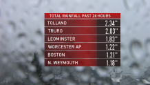
The heaviest rain was in southern New England on Monday morning. Rivers continue to run high, and in some cases out of their banks. And there were a few street flooding rescues in communities north of Boston.
Monday's weather dynamic features a cooler high-pressure system pressing in from southeastern Canada, with surface wind from the northeast at 10 to 15 mph. At the same time, warm and humid air is pushing at us from the south, riding over the top of the more dense air near the ground. There’s actually a heat advisory in New Jersey on Monday, where temperatures are in the 90s, even as Boston stuck in the 60s after topping out near 70 before sunrise.
Get Boston local news, weather forecasts, lifestyle and entertainment stories to your inbox. Sign up for NBC Boston’s newsletters.
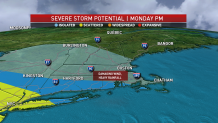
This weather boundary, or front, is stalled near our South Coast. That is where we could see the risk for thunderstorms Monday afternoon -- some with the potential to generate damaging wind and heavy rainfall.
Steady rain has tapered to showers, with patchy fog and drizzle for most of us Monday afternoon and evening. There is sunshine in far northern Maine, where temperatures made it close to 80 degrees. Another batch of rain will come through Monday night as another wave of low pressure goes along the front to our south. Then Tuesday will probably be a mostly cloudy day with lighter showers and also fog and drizzle. Wind will continue to come in from the east at 10 to 15 mph.
Local
In-depth news coverage of the Greater Boston Area.


Warmer air is on our doorstep Wednesday, but it’s very sticky, with many clouds and a few showers or a thunderstorm as the temperature goes back up to 80 degrees for most of New England.
We are hot here Thursday, Friday, and Saturday.
There’s a chance of thunderstorms west Thursday afternoon, then pressing east later Friday into Saturday. It looks once again like a front could stall over us for the weekend, with chances for showers and thunderstorms continuing as we gradually cool toward the beginning of next week.
Stay tuned to the latest developments in our First Alert 10-Day Forecast.