
It has been snowing somewhere in New England since Sunday night, day three of a waning nor’easter.
We are not expecting too much significant weather Wednesday, but there is some more splash over at high tide with the seas still churning on Wednesday afternoon.
Get top local stories in Boston delivered to you every morning. Sign up for NBC Boston's News Headlines newsletter.
We also have some scattered snow showers with the upper level low now crossing New England. The surface storm has moved on into Canada, so the wind has relaxed and come around now more from the west/northwest, a drier weather direction.
Temperatures are seasonable Wednesday afternoon in the 30s, just warm enough that any light snow mostly melts, especially on treated surfaces.
We have partial clearing overnight, with a little bit colder air, some patchy black ice, low temperatures in the 20s and a late night moon.
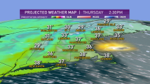
Thursday looks pretty good, with plenty of sunshine and high temperatures in the 30s. There is a blizzard in Iowa on Thursday, and that storm is going to push into Canada with a front entering New England.
Actually two fronts, first a warm front with some freezing rain to rain in southern New England, and snow to freezing rain central and north. Then a cold front at night with a chance of snow showers back down to the coast by Saturday morning.
Local
In-depth news coverage of the Greater Boston Area.


It’s a fairly energized system with a chance of a thunderstorm near Cape Cod Friday evening.
Highs on Friday will be in the 30s north to low 40s south to near 50 degrees on Cape Cod.
Colder and drier air is going to blow in Friday night and Saturday.
Saturday is a brisk mix of sun and clouds, high temperature in the 20s north and 30s south.
Another front is going to come through on Sunday, and there’s a chance of a storm forming on that front, but we’re pretty uncertain right now, so we’re just calling it a chance of a snow shower or a snow squall, with temperatures near freezing.
That’s the leading edge of much colder air, with temperatures mostly in the 20s next week.
There will be an ocean storm forming, or several ocean storms forming from Sunday night through mid week, but it’s all low confidence.
The highest confidence is the chill coming in next week in our First Alert 10-Day Forecast.