
Snow has taken over for most of New England, though drier air has kept moisture south of northern New England entirely.
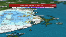
That same cold and dry air, feeding into the storm system on a north wind that’s downed a few isolated trees in southeast Massachusetts, has flipped rain to snow all the way into interior southeast Massachusetts, where the rain/snow line remains stalled into Friday afternoon until precipitation is ready to taper in intensity during the mid-afternoon, then tapers entirely Friday evening after dropping two to three inches for many in Metrowest and points north and west, one to two inches farther east and in central Vermont to central New Hampshire, and only a coating in parts of southeast Massachusetts.
Use caution on roadways that have become snow and ice covered for much of interior southern New England and will be subject to black ice overnight as the temperature drops below freezing for all but the mid and outer Cape.
Halloween looks bright and cool, with dry air providing plenty of sunshine but highs only in the 40s, dropping to around 40 by trick or treat time.
Get top local stories in Boston delivered to you every morning. Sign up for NBC Boston's News Headlines newsletter.
An energetic storm system in southern Canada turns our winds from the south Sunday, which appears likely to catch a disturbance to our south and deliver it to eastern New England with a building chance of showers from south to north during the late morning through afternoon. That same south wind will also bump temperatures well into the 50s and even near 60 for some, with gusts to 40 mph.
Local
In-depth news coverage of the Greater Boston Area.


Showers will continue Sunday evening and night ahead of one installment of cool air Monday, then another cold front will reinforce the chilly air for Election Day, with a fair sky expected but high temperatures only either side of 40 degrees.
Once the election is over, moderation begins, with temperatures reaching the 60s by the end of next week and mostly dry weather in our exclusive First Alert 10-day forecast.