Northern New England is gearing up for the first big snowstorm of the season. Meanwhile in Boston, we will have plain rain thanks to milder air and an onshore wind.
Before we get to the wintry mess, our temperatures Tuesday morning have dropped to the 20s and 30s all over the northeast. A killing frost or freeze was found in more places in southern New England, with thick frost on car windshields parked outside overnight.
Tuesday's Conditions
Get Boston local news, weather forecasts, lifestyle and entertainment stories to your inbox. Sign up for NBC Boston’s newsletters.
The wind is the difference Tuesday, too. A light breeze is out there, but it's not nearly as strong as Monday, so temperatures Tuesday in the mid 40s will actually feel much better to us. The clouds thicken up as the day goes on, but we hold off on any precipitation until late Wednesday and after the evening commute.

When Is It Going to Snow, and How Cold Will It Get Overnight?
Lows tonight will be in the 20s and 30s north and cold enough to support snow. Southern and eastern New England will be in the 40s with increasing temps into the morning, so this supports rain.
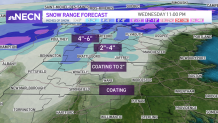
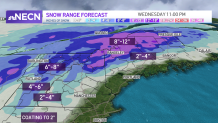
An easterly wind picks up by Wednesday morning, with the development of a coastal low. That low passes over southeastern New England mid morning Wednesday. Colder air is locked into Vermont, New Hampshire and Maine, so all snow is forecast through Wednesday afternoon.
How Many Inches of Snow Will We Get?
Rain will be around south overnight, through Wednesday afternoon. By late afternoon, only a few rain showers remain around Boston. The freezing line will be around 495, the Tolland Hills, and the Route 2 corridor. So that's where we can see a coating to 2 inches of snow overnight, changing over to rain by late Wednesday morning.
Temperatures warm to 50 to 60 degrees south and east for Wednesday! Then our wind flips and we cool off for the rest of the week.

Snow Day Calculator
Will any schools decide to delay or cancel school on Wednesday? We won't know for sure until later in the day on Tuesday or possibly even Wednesday morning. But you can check all of the latest school closings on NBC10Boston.com's school closings page.
What's Next?
Highs return to the 30s and 40s for Thursday and Friday as we get a gusty westerly wind. There is enough lift, moisture, and instability so we will watch for isolated snow squalls in the mountains both afternoons. High pressure takes over and that means dry weather and sunshine for southern New England. Overnight lows will be in the 20s to teens for a true late fall feel.
We remain in the low 40s through the weekend with an isolated snow/mix shower chance Sunday inland.
More on Wednesday's snowstorm
Be prepared for your day and week ahead. Sign up for our weather newsletter.


