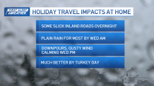
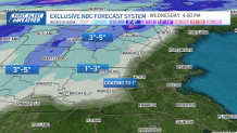
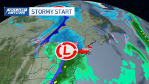
A low pressure is increasing cloud cover across New England. Rain and snow enter by Tuesday evening for central and western New England.
This comes overhead and will bring snow to the higher elevations. The valleys will see a rain/snow mix and plain rain. Wednesday morning as the sun comes up, most areas will be seeing all rain, and the temperatures rise, losing most slickness and tricky travel by Wednesday afternoon.
Some accumulations are possible for northern New England and interior New England. The highest peaks of the Green and the White Mountains will get in on the highest snow accumulations, near 6 inches.
Get Boston local news, weather forecasts, lifestyle and entertainment stories to your inbox. Sign up for NBC Boston’s newsletters.
Boston will likely see rain Tuesday evening, and rain and wind chances stay with us through the morning Wednesday. Tricky travel is likely, as 1-2 inches of rain is possible. You should anticipate reduced visibility along with the pre-holiday traffic.
Thanksgiving will be one of the warmest of the next 10 days and mainly dry. Temperatures will be in the 50s on Thanksgiving Day; otherwise, the 10-day forecast features many 40s for highs and 20s for lows. The next rain and wintry mix chances come in Sunday into Monday.