After a beautiful fall weekend for much of the region, clouds and some showers have returned to the Northeast.
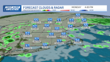
Energy in the upper levels of our atmosphere is swinging through Monday, serving as the trigger for these sporadic showers. It won't be a washout by any means but there will be some raindrops to dodge from time to time. Temperatures will be cooler than normal too, running in the 50s this afternoon.
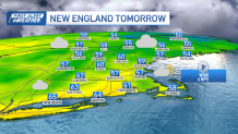
We'll drop into the 40s Monday night with many clouds remaining in place and some additional showers cropping up at the coast. It will be a similar day Tuesday with a hit or miss shower, many clouds and highs in the 50s.
Get Boston local news, weather forecasts, lifestyle and entertainment stories to your inbox. Sign up for NBC Boston’s newsletters.
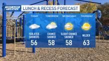
We do turn brighter by Wednesday, and though an isolated shower or sprinkle is possible, the chance is much lower overall, around 30%. High pressure will take a firmer hold on our weather for Thursday -- which is my pick of the week -- providing us with ample sunshine and a warming trend; we'll be well into the 60s.
An approaching disturbance on Friday, which is currently out over the Pacific Ocean, will result in increasing clouds again and developing showers particularly during the afternoon.
The showers are likely to turn to an area of steady rain Friday night into the first part of Saturday as it looks right now with some lingering wet weather in Northern New England on Sunday.
There's still plenty of wiggle room for the forecast to shift.
Behind the weekend disturbance, chilly air may be just cold enough to transition some leftover shower to wet snowflakes with elevation in far northern New England later Sunday. After that, cooler but quieter weather takes hold for next week as seen in our exclusive 10 day forecast.