
Sunday officially marked the hottest day of 2020 for the city of Boston. The last time we were this warm was 11 months ago, back on August 19, 2019.
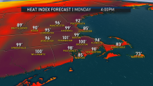
Other locations in New England hit the mid and upper 90s. We have one more 90-degree day to make this a heatwave and that happens Monday. At this point, the temperature might not be as high on Monday, but it will be even more humid. The heat index will reach 100° in many communities.
Showers and thunderstorms are possible during the afternoon on Monday. This cold front has had a history of producing significant damage across the northern plains in Great Lakes. That doesn’t guarantee severe weather, in fact it doesn’t look like we will see widespread severe weather. Whatever storms we do see will be isolated, but the ones that do form could be strong to severe.
Click here for active weather alerts

Tuesday will stay warm, and for some communities it will be day four of the heat wave. Humidity levels will be significantly lower. It looks like a fantastic beach day with high temperatures approaching 90 degrees.
Local
In-depth news coverage of the Greater Boston Area.


A warm front lifting in Wednesday and Thursday will bring showers and thunderstorms. It’s possible that some storms could be strong. Right now, the greatest risk looks to be heavy rain. The air mass turns increasingly muggy, especially on Thursday.
Temperatures into next weekend remain in check, with a couple of showers and thunderstorms continuing.
