
New England has faced hurricane-force wind speeds Friday morning, gusting at 74 mph in southeastern New England.
Tens of thousands of residents lost power and heavy rain produced over 2 inches of accumulation in some spots. Numbers keep adding up as the rain keeps pushing north. There was major flooding along Rhode Island's coast, while parts of southeastern Maine were under a flash flood warning.
See severe weather alerts and school closings in your area.
Get Boston local news, weather forecasts, lifestyle and entertainment stories to your inbox. Sign up for NBC Boston’s newsletters.
Another round of strong wind, this time from the southwest, will gust over 60 mph in the southeast mid-afternoon into the early evening Friday. At that time, the cold front will rush in, crashing temperatures down to the 30s and enhancing the chance for a flash freeze in some untreated roads with leftover moisture.
Additional power outages may be a risk at the same time that temperatures plummet down in the evening and overnight.
UNBELIEVABLE PHOTOS! Storm Socks Boston Area With Rain, Wind
Local
In-depth news coverage of the Greater Boston Area.


Reports of coastal flooding came in Friday morning in Buzzards Bay. Portland, Maine, estimated a historic high tide of 14 feet with the late-morning high tide, while splash-over and minor coastal flooding remains a concern for the south- and east-facing beaches during Friday evening’s high tide.
With the passage of the cold front Friday evening, some rain will switch over to snow as it comes down through Vermont, New Hampshire and western Massachusetts. The interesting thing is that, while eastern Massachusetts will have a hard time getting any of those flurries, the coast will face ocean-effect snow showers that may bring up to 2 inches of snowfall.
In isolated areas, these snow totals may add up to 4 inches along the coast of Connecticut, extending Cape Cod and the Islands.
The wind will begin to die down overnight but will continue to gust over 30 mph Saturday, meaning that the wind chill will play a critical role Saturday morning and afternoon.
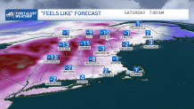
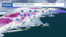
Highs are set to reach the 20s Saturday, but the wind will bring down the chills to feels-like temperatures below 0 in the morning hours and in the single digits through the afternoon! Layers, scarves, winter coats and gloves will be needed if planning to go outdoors this holiday weekend.
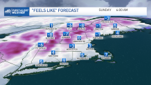
Saturday will bring the coldest wind chills but Sunday, Christmas Day, keeps temperatures the upper 20s and feeling in the teens through the sunny afternoon.
In the 10-day forecast we’ll keep the cold trend of below-average highs through mid-week until a warmer weather pattern returns on the second half of the work week. The following weekend keeps us with the potential of some unsettled & milder weather right on time for the New Year.
