
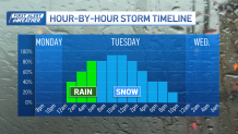
As a nor'easter approaches Tuesday New England is preparing for a storm that could drop a foot of snow in some areas. Schools have already announced closures, with more expected as the storm moves closer, but as of Monday afternoon we're watching some new patterns emerging that will change where we expect to see the most snowfall.
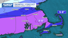
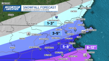
The low pressure or Nor'easter is trending further south off the coast. This southward shift impacts snow totals for the Merrimac Valley and the North Shore.
While the highest impacts have taken a southward shift, we're still expecting heavy snow, gusting wind, and coastal flooding. Boston will still be in the thick of it by mid-morning Tuesday.
Get Boston local news, weather forecasts, lifestyle and entertainment stories to your inbox. Sign up for NBC Boston’s newsletters.
Estimated snow totals
Snow comes in by 7 a.m. with the heaviest bands tapering off for Central Mass and Eastern Mass by the late afternoon and early evening. Bands of snow linger for Cape Cod into the late evening. The highest coastal flood potential is paired with high tide, around 2 p.m. and during the new moon and astronomical high tide, from the New Hampshire coast to Cape Cod. This push of high water will impact coastal roads and flood prone areas with 1-3' of inundation possible.
Local
In-depth news coverage of the Greater Boston Area.


The storm is expected to taper off by late afternoon and move out of the area by sundown. More on the timing here.
Be prepared for your day and week ahead. Sign up for our weather newsletter.
