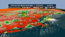
Just as one front moves offshore to our east and we see some sunshine today, the next front is right on our doorstep. We will see more showers and thunderstorms by this afternoon and tonight.
We do not have very much fog around this morning for a change, which means plenty of sunshine through about lunchtime before building cumulus clouds.
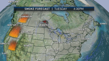
Though we are talking sunshine, smoke from western fires may be fairly thick high up in the sky, resulting in a brown or white hue.

Get Boston local news, weather forecasts, lifestyle and entertainment stories to your inbox. Sign up for NBC Boston’s newsletters.
There will be a few showers and thunderstorms developing in western and northern New England by mid afternoon if not sooner. For most of southern New England it should be a dry day. Temperatures top out near 90° south, in the 80s north.
Along the South Coast, wind from the southwest is gusting past 20 miles an hour, but for most of New England it’s a light wind. From Boston and points north that could be a weak sea breeze developing. It’s a rather sticky day so when showers and storms do develop, they could turn into downpours very quickly.
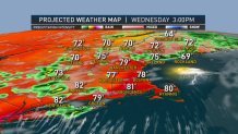
The next front is coming in from southern Canada. There will be waves of low pressure rippling along as the front slows and stalls over southern New England once again. It’s the same old story with potential downpours tonight and tomorrow, scattered strong to severe thunderstorms and possible localized flash flooding.

Though the thunderstorms are not that widespread, they’re fairly slow moving. We may generate one to three inches in some of the downpours, especially late today through most of tomorrow. It will be humid tonight with a low temperature in the 60s north and 70s south.
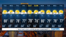
Tomorrow features more widespread showers and thunderstorms at all hours of the day, with high temperatures in the 70s to lower 80s. The front looks like it will push east tomorrow night and Thursday looks good.

We should have fairly strong high pressure coming at us from Canada with lower humidity and a good amount of sunshine. But it does not last long.
Weather Stories
The next warm front should be on our doorstep later Thursday with a return to showers and thunderstorms Friday. And that front may keep on moving for a change, allowing for a return to sunshine for at least the start of the weekend, before the next front and some more showers possible by later Sunday.
Stay tuned to the latest developments in our first alert 10 day forecast.


