
We'll see continued unsettled weather this evening and into the overnight as another wave of low pressure moves through New England.
Expect conditions to remain overcast through early tonight with some patchy fog and drizzle as well as a few passing showers. Southern New England, especially southeastern areas may see some gusty winds as well as low pressure approaches from the south. With colder air in place, far northern Maine will see a wintry mix of snow, sleet, and freezing rain with a light accumulation possible.
STAY IN THE KNOW
Watch NBC10 Boston news for free, 24/7, wherever you are. |
|
Get Boston local news, weather forecasts, lifestyle and entertainment stories to your inbox. Sign up for NBC Boston’s newsletters. |
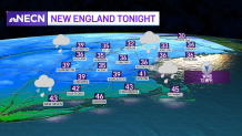
Overnight, another batch of precipitation moves into the area from the south, mainly rain across southern New England, a wintry mix of snow and sleet far north where we could see several inches of snow across far northern Maine by Friday morning. Lows will range from the upper 30s to low 40s south, low to mid 30s north.
Get top local stories in Boston delivered to you every morning. Sign up for NBC Boston's News Headlines newsletter.
Friday will feature drier and milder conditions as winds turn more out of the west with the only exception of far northern New Hampshire and into northern Maine, where we’ll remain cool with wintry conditions once again through the early afternoon.
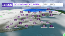
The day will start out with some patchy fog south, but by the afternoon, we should see some sunny breaks helping warm temperatures up into the mid 50s to low 60s. A spot afternoon shower is still in play, but overall we should remain dry. Temps will reach the 50s central New England, 40s northern New England, 30s far north.
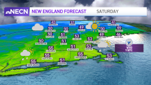
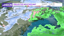
Over the weekend, an upper-level system will be our dominant feature as it slowly moves through the region. With cold air aloft, we’ll see "building" afternoon clouds both Saturday and Sunday with temps close to average, 50s south, 40s north with the risk for showers south, rain/snow showers north. We may even see some small hail as well as graupel at times. Late Sunday, a cold front slides through the region bringing more rain/snow showers as well as windy conditions and unseasonably cold temperatures which will remain with us through early next week.