
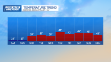
Your Saturday morning begins with wind chills in the single digits above and below freezing. A frigid weekend is ahead. For Saturday, temperatures will stay 10-20 degrees below normal, with wind gusts near and above 20 mph.
Cloud cover is expected due to a shortwave, limiting sunshine. Highs will be in the teens to low 20s, and it will be gusty.
There's a slight chance of spotty snow showers in far northwestern Massachusetts during the afternoon, but no significant impacts are expected.
Get Boston local news, weather forecasts, lifestyle and entertainment stories to your inbox. Sign up for NBC Boston’s newsletters.
Sunday will start similarly, with feels like temperatures below 0. Sunday afternoon begins a warming trend that will continue into the middle of next week.
Highs on Sunday will be in the upper 20s, but by Monday, highs rise above freezing. We will remain in the low and middle 40s for much of next week. An unsettled pattern will be entering with the warmer air. Multiple rounds of precipitation throughout the week, the first one comes in late Tuesday into Wednesday.
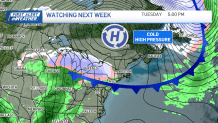
This system has the potential to start as snow initially, but as temperatures rise, the precipitation may change to a mix and eventually rain. Then the next system comes in on the tail of the first and looks to bring rain Thursday into Friday.
Weather Stories


Be prepared for your day and week ahead. Sign up for our weather newsletter.
