
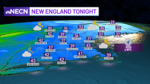
We’ll remain mostly cloudy and on the cool side this evening with very isolated sprinkles and showers through early tonight. Clouds remain in place overnight preventing temperatures from really dropping as high pressure settles into the region. Lows tonight will range from the low to mid 40s south, 30s inland, upper 30s to around 40 north with a light northeast wind.
STAY IN THE KNOW
Watch NBC10 Boston news for free, 24/7, wherever you are. |
|
Get Boston local news, weather forecasts, lifestyle and entertainment stories to your inbox. Sign up for NBC Boston’s newsletters. |
A dry but cloudy start to your Monday
High pressure keeps us dry and mild as we start out the new work week, but we’ll see more clouds than sun in the forecast Monday. Highs across western areas of New England will reach the mid to upper 60s, upper 50s to low 60s towards the east, and 50s along the immediate coastline where we’ll continue to see onshore breezes. Wind will slowly switch from the east to south by late in the day which may allow for some coastal communities such as Boston to see a bounce up in late afternoon temperatures.
Get top local stories in Boston delivered to you every morning. Sign up for NBC Boston's News Headlines newsletter.

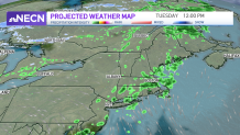
Next chance for rain comes Tuesday
A cold front will slide through the region during the day Tuesday producing scattered showers for much of the region. Low pressure will develop along the frontal boundary south of New England late in the day keeping the threat for showers in the forecast Tuesday night through Wednesday morning.
Beyond that, low pressure will be stubborn to exit as it remains over Nova Scotia keeping much of northern New England in a cool, damp pattern with occasional rain showers and mountain snow showers through late in the week. Southern New England looks to remain seasonable through the end of the week, but can’t rule out a few isolated showers, especially across eastern areas Thursday.