
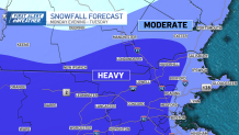
Here's a look at our early snow map for Tuesday
We’re really ramping up the weather intensity in the coming days. The pendulum swings from warm to cold and the pattern spins up a robust winter storm by Monday night. Then it’s all about the cold into Valentines Day and beyond, so whatever snow we receive is likely to stick around for a while.
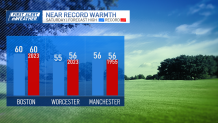
Firstly, the record-setting temps today. Sunshine should help us climb to the low 60s in spots across Metrowest, the Shawsheen Valley (Bedford, Wilmington, Billerica, Tewksbury, Andover) and the Merrimack Valley/Southern New Hampshire this afternoon.
Get Boston local news, weather forecasts, lifestyle and entertainment stories to your inbox. Sign up for NBC Boston’s newsletters.
This is the “hot zone” in these kinds of setups, and outside of this zone, we’ll be less likely to see the temperatures soar. That’s not to say we’re out of the running for warmth in Boston. We should still hit 60 and tie the record. Same goes for Worcester, with a high near the record of 56. Cooler 50s are expected on the North Shore, Cape Ann and the South Shore from Brockton to Wareham. Unfortunately, only 40s on Cape Cod and the Islands today.
Showers will pop up along a front late this afternoon and evening. There’s enough energy (and warmth) to even spark a thunderstorm in Western/Central Mass! IF they form, they will quickly weaken as they move into Eastern Mass after dark.
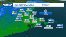
Cooler air swings in Sunday amidst a LOT of clouds and a little sun. Cooler is relative, however. We’re still expecting highs near 50. Monday dips even more – mid/upper 40s – as the stage is set for our winter storm.
Track issues still plague us. Marginal cold does too. But this storm contains some very impressive energy that could overcome both limiting factors. Heavy amounts are expected, with 6 +/- as the middle ground, for many away from the coast. The issue of course, is HOW FAR from the coast? That will come into focus in later forecasts.
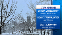
At this point, we can plan on the startup late Monday night and continuing through Tuesday. Strong winds are possible right at the coast, and the winds will help in creating coastal flooding during the high tide cycles (particularly the 1pm high tide Tuesday). Heaviest snow is an elusive point right now, but it appears to be in the early part of Tuesday.
Plenty more fine-tuning in the days ahead. We’re online, on-air, on social, and on your favorite streaming platform.
Enjoy the weekend!


