
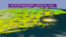
The high-pressure system that brought such cold air the last few days is moving offshore. Now the return flow from the south is bringing in warmer weather -- along with a good amount of sunshine -- for a great looking St. Patrick’s Day afternoon and evening, with temperatures near 50 degrees.
STAY IN THE KNOW
Watch NBC10 Boston news for free, 24/7, wherever you are. |
|
Get Boston local news, weather forecasts, lifestyle and entertainment stories to your inbox. Sign up for NBC Boston’s newsletters. |
There’s a serious storm in the south, though. Blizzard warnings are in effect in north Texas, but on the warm side of that storm, the big story is the tornado threat Wednesday -- especially centered in Mississippi. Long tracked powerful tornadoes are expected throughout the afternoon and evening.
The center of that low pressure system is going to move into West Virginia Wednesday night, and spread rain into New England on Thursday.
Get top local stories in Boston delivered to you every morning. Sign up for NBC Boston's News Headlines newsletter.
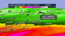
Because we are not going to get into the real warm and humid sector, no severe weather or thunder is expected here. We could use some rain, and parts of southern New England may get close to an inch.
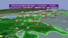
After a fair night with low temperatures in the 30s to near 40 degrees, we will have a little bit of sunshine Thursday morning before clouds race in and rain develops in western New England by 1 p.m., if not sooner.
The temperature should get into the lower 50s before the rain cools us back to the 40s.
It’s not only low pressure tracking to our south, there’s also a cold front coming from the north. That may bring a little snow to northern Maine early in the day, but more importantly, it’s going to push colder air in and we will see rain changing to snow in central and southern New England on Thursday night.
It may snow hard for a few hours just before the sun comes up Friday along and south of the Massachusetts Turnpike.
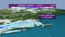
Some of the hills may get 3 inches of snow. Lower elevations and especially the coast probably end up with closer to no accumulation, but deep slush puddles are possible first thing Friday.
Local
In-depth news coverage of the Greater Boston Area.


A series of low pressure systems will track south and east of Nantucket, perhaps keeping the precipitation going on Cape Cod through late morning. It is a moderate nor’easter for southeastern Massachusetts.
The sun should come out in most of New England by lunch time Friday. Temperatures on Friday will only be in the 30s, with the wind gusting past 25 mph -- more like 40 mph in southeastern Massachusetts and the Maine coast.
Cold high-pressure from Canada will clear out the sky Friday night, with temperatures back down to the teens in low 20s.
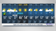
High pressure comes right over us on Saturday. It will be a beautiful day for the vernal equinox -- that’s when the calendar turns into spring. With sunshine and fairly light wind, high temperatures should be in the 40s.
As that high moves offshore, we should have a warmer flow on Sunday. After a cold start, we get back into the lower 50s away from the coast.
There will be another storm forming off the southeastern United States. We will have to watch that next week. It probably stays away, but may help keep an onshore breeze going.
So while most of New England should warm up to the 50s to low 60s next week, it may stay significantly cooler at the beaches, as seen in our First Alert 10-Day Forecast.