
-
Weather forecast: Cold wind blows
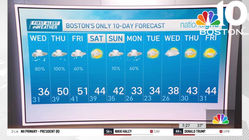
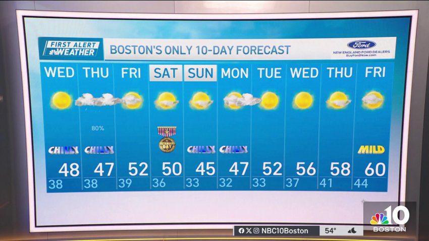
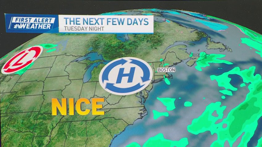
Thursday night: Clear with a wintry wind. Lows around 20, wind chill single digits. Friday: Sun to increasing clouds, less wind. Highs around 40. Saturday: Rainy, breezy. Northern New England winter storm. Highs in the 40s, 50s south.
-
Cold night, chilly Friday ahead for Boston
Thursday evening: Blustery, clear, a few flurries and northwest gusts to 40 mph. Temps in the 30s, wind chill 20s. Overnight Thursday night: Clear with a wintry wind. Lows around 20, wind chill single digits. Friday: Sun to increasing clouds, less wind. Highs around 40. Saturday: Rainy, breezy. Northern New England winter storm. Highs in the 40s, 50s south.
-
Weather forecast: Cold and windy, with temps feeling like 10 to 20 degrees
Thursday: Blustery with fair sky, a few flurries and northwest gusts to 40 mph. Highs in the 30s, wind chill 20s.
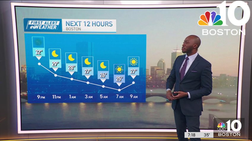
Overnight Thursday night: Clear with a wintry wind. Lows around 20, wind chill single digits.
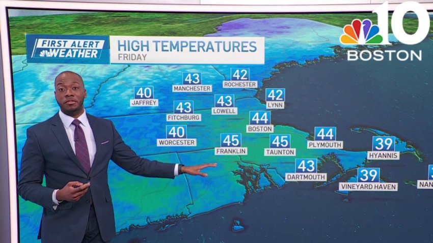
Friday: Sun to increasing clouds, less wind. Highs around 40.
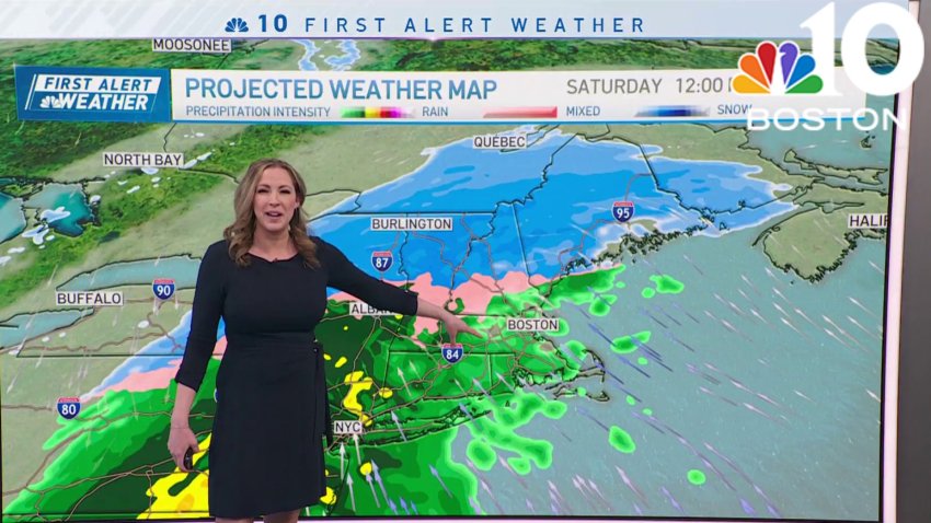
Saturday: Rainy, breezy. Northern New England winter storm. Highs in the 40s, 50s south. -
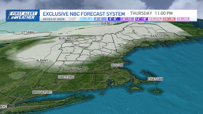
Wintry weather returns, heavy snow in northern New England this weekend
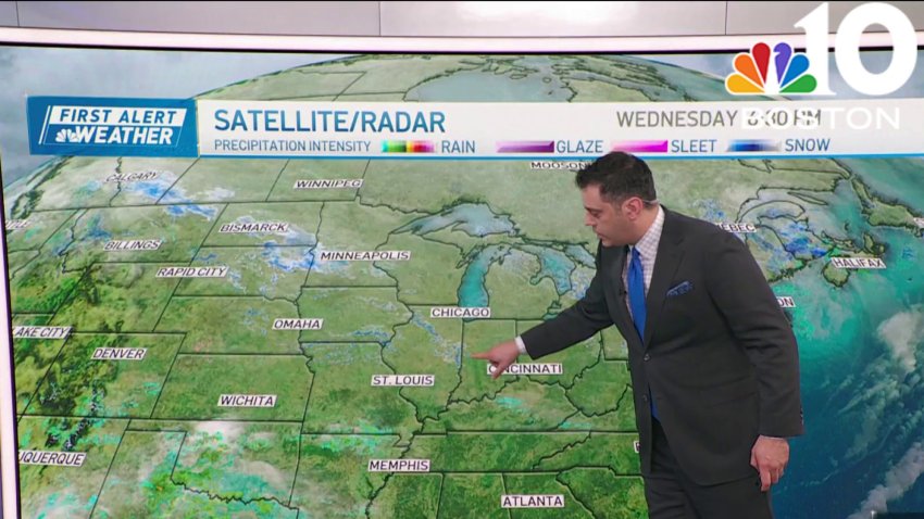
Winter has returned in full force on Thursday with gusty west winds, wind chills in the teens and 20s, highs in the 30s, and some lingering flurries. More specifically, in Maine we continue to see the low pressure system slowly move out Thursday, but lingering snow showers continue to coat untreated backroads with fresh snow. The morning flurries across...
-
Blustery in Boston Thursday, with wind chills in the 20s
Thursday: Blustery with fair sky, a few flurries and northwest gusts to 40 mph. Highs in the 30s, wind chill 20s.
Overnight Thursday night: Clear with a wintry wind. Lows around 20, wind chill single digits.
Friday: Sun to increasing clouds, less wind. Highs around 40.
Saturday: Rainy, breezy. Northern New England winter storm. Highs in the 40s, 50s south. -
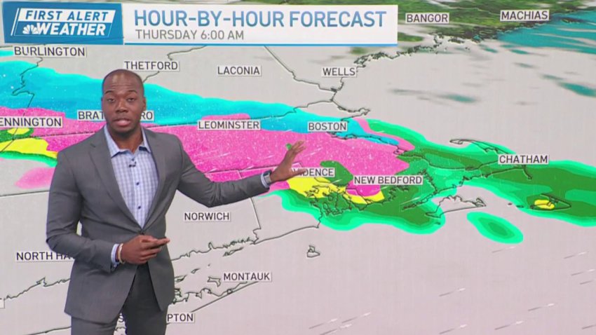
Forecast: Snow moves through overnight
Overnight Tonight: Light snow. Accumulations generally a coating to 2″, highest amounts farthest inland. Lows around 30. Wednesday: Periodic light snow and ice to rain showers. Highs in the 30s. Thursday: Milder with showers. Night rain. Highs around 50.
-
Light snow, wintry mix coming to Mass., New England
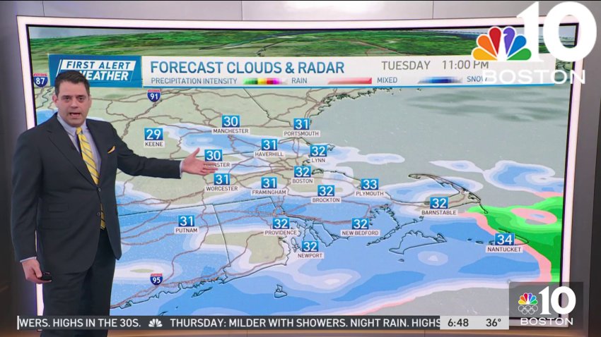
Tuesday: Limited sun to clouds with light snow and mix deep inland. Highs around 40.
Overnight Tuesday night: Light snow. Accumulations generally a coating to 2″, highest amounts farthest inland. Lows around 30.
Wednesday: Periodic light snow and ice to rain showers. Highs in the 30s.
Thursday: Milder with showers. Night rain. Highs around 50. -
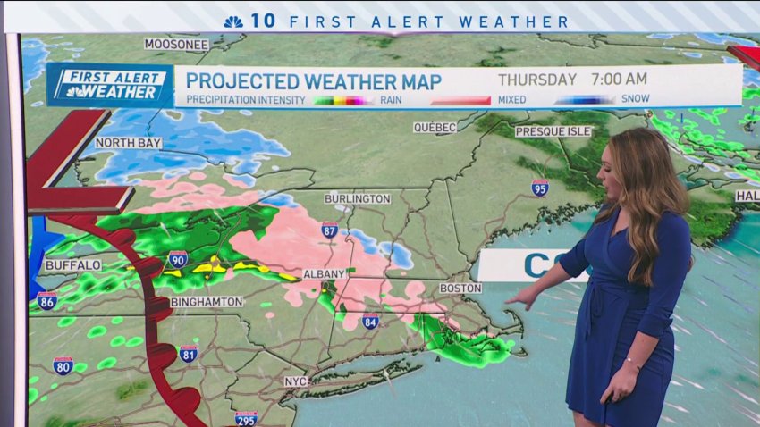
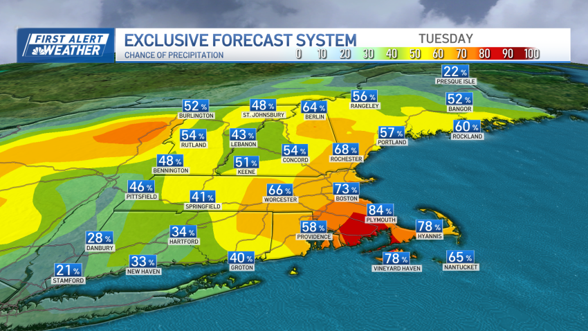
Snow returning Tuesday in Mass., New England: What to expect
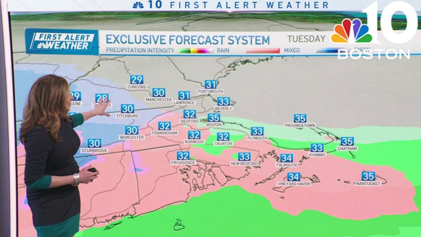
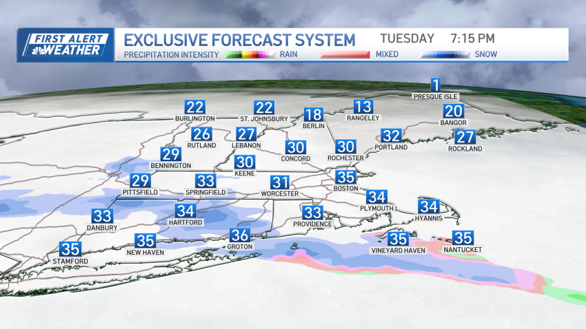
Here’s how much snow to expect around Boston and the rest of Massachusetts as a cold front moves into the area Tuesday night into Wednesday.
-
Cloudy day in Boston Tuesday, snow and rain arrive in the afternoon
Tuesday: Limited sun to clouds with light snow and mix deep inland. Highs around 40.
Overnight Tuesday night: Light snow. Accumulations generally a coating to 2″, highest amounts farthest inland. Lows around 30.
Wednesday: Periodic light snow and ice to rain showers. Highs in the 30s.
Thursday: Milder with showers. Night rain. Highs around 50. -
Forecast: Temps plummet tonight
Overnight Tonight: Partly cloudy. Gusty winds continue, with gusts up to 35 mph. Lows in the 30s.
Wednesday: Brisk sun with a nippy wind. Highs only in the 40s.
Thursday: Mixed rain/snow showers to rain showers. Highs in the 40s. Friday: Mostly cloudy. Highs near 55. West wind at 10-20 mph. -
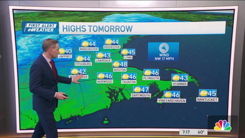
Forecast: Brisk air with nippy wind on Wednesday
Overnight Tonight: Partly cloudy. Gusty winds continue, with gusts up to 35 mph. Lows in the 30s.
Wednesday: Brisk sun with a nippy wind. Highs only in the 40s.
Thursday: Mixed rain/snow showers to rain showers. Highs in the 40s. Friday: Mostly cloudy. Highs near 55. West wind at 10-20 mph. -
Forecast: Warmth moves out for late-week rain, wintry mix
Overnight Tuesday night: Partly cloudy. Gusty winds continue, with gusts up to 35 mph. Lows in the 30s. Wednesday: Brisk sun with a nippy wind. Highs only in the 40s. Thursday: Mixed rain/snow showers to rain showers. Highs in the 40s. Friday: Mostly cloudy. Highs near 55. West wind at 10-20 mph.
-
Looks like the remainder of Tuesday stays dry
Today: Early showers to emerging sun and a mild breeze. Quick late day shower. Highs in the 60s. Overnight Tonight: Partly cloudy with a cool breeze. Lows in the 30s. Wednesday: Brisk sun with a nippy wind. Highs only in the 40s. Thursday: Mixed rain/snow showers to rain showers. Highs in the 40s.
-
From 60s to snowflakes: Brief warmth Tuesday, wintry mix possible Thursday
Get ready for a bit of a shock to the system. Mild and breezy conditions are expected in New England Tuesday as low pressure tracks north of the region. The area will reside in warm air through much of the day, with a southwest breeze gusting as high as 35 mph at times near the South Coast and steady at…
-
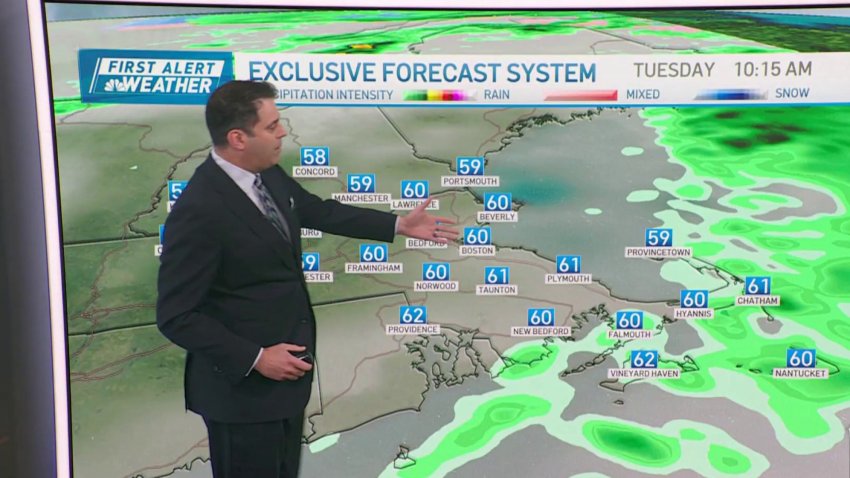
Tuesday's temperatures expected to be well into the 60s
Today: Early showers to emerging sun and a mild breeze. Quick late day shower. Highs in the 60s. Overnight Tonight: Partly cloudy with a cool breeze. Lows in the 30s. Wednesday: Brisk sun with a nippy wind. Highs only in the 40s. Thursday: Mixed rain/snow showers to rain showers. Highs in the 40s.
-
Weather forecast: Lows in the 40s
Monday night: Mostly cloudy. Coastal showers. Lows in the 40s. Tuesday: More clouds than sun, isolated shower. Highs 55-60. Wednesday: Partly cloudy, chance shower. Highs 60-65.
-
Forecast: More showers on the way before sunny stretch
Overnight Monday night: Mostly cloudy. Coastal showers. Lows in the 40s. Tuesday: More clouds than sun, isolated shower. Highs 55-60. Wednesday: Partly cloudy, chance shower. Highs 60-65.
-
Forecast: More wet weather on the way
Monday: Passing showers, glimpses of sun. Highs in the 50s. Overnight Monday night: Coastal showers. Lows in the 40s. Tuesday: More clouds than sun, isolated shower east. Highs 55-60. Wednesday: Partly cloudy, chance shower. Highs 60-65.
-
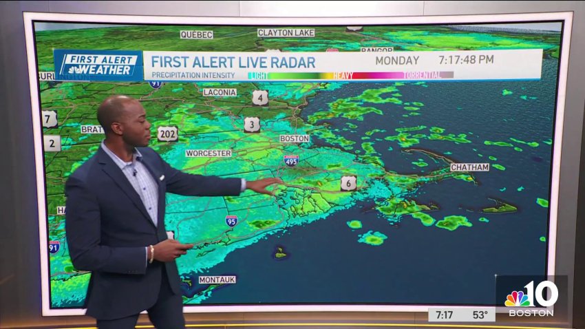
Spotty showers Monday — here's when things will clear up (live radar)
After a beautiful fall weekend for much of the region, clouds and some showers have returned to the Northeast. Energy in the upper levels of our atmosphere is swinging through Monday, serving as the trigger for these sporadic showers. It won’t be a washout by any means but there will be some raindrops to dodge from time to time....
-
On-and-off showers on Monday with cooler temperatures
Today: Passing showers, glimpses of sun. Highs in the 50s. Overnight Tonight: Coastal showers. Lows in the 40s. Tuesday: More clouds than sun, isolated shower east. Highs 55-60. Wednesday: Partly cloudy, chance shower. Highs 60-65.
Trending
