
Overnight snow is on the way out Wednesday morning. There still may be some slippery spots, so take it slow and easy on the roads. Temperatures will bounce back above freezing in many spots, aiding the melt and creating a damp, messy feel to the day.
Any mix, rain or snow Wednesday is spotty and light. No additional accumulation is expected as we sit in between batches of precipitation.
Our next round arrives Wednesday night and spills into Thursday morning. It will fall mostly as rain, but some light icing is possible in western Massachusetts. Temperatures slowly creep up near 40 by morning.
Get Boston local news, weather forecasts, lifestyle and entertainment stories to your inbox. Sign up for NBC Boston’s newsletters.
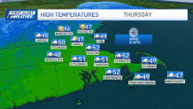
We're much milder Thursday as we bust into the low 50s in many spots. Showers continue, but there may be a break in the afternoon. Friday features the last bout of rain with some more afternoon drying.
It sounds like a lot of water is coming our way, but much of this is light rain, and many of us will be under an inch of water by the time the last drops fall Friday.
The weekend sees us square off with a much larger storm system, capable of strong winds, heavier precipitation, and accumulating snow.
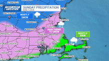
We feel that initially the air will be too warm for snow near the coast, but inland and north, the snow may get cranking early on Sunday. As colder air is swept up into the storm, that snow should descend to the coast — and perhaps to the Cape at the tail end of the storm Monday morning.
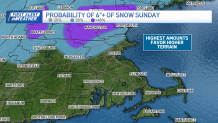
Where we start or switch to snow early, the amounts obviously will be highest. Right now, the guidance is bullish on up to 6 inches in the higher terrain of Central Mass.
Plenty of details to work out in the days ahead. In the meantime, stay dry!


