It was nice to finally see the sun on a Saturday! The past few weeks it seems as though we couldn’t catch a break with inclement conditions, but today we were rewarded with wall-to-wall sunshine for most of the day and overall seasonable temperatures!
If you have plans Saturday evening, you’ll definitely need a jacket as temperatures drop off a bit as the sun sets, but we’re not seeing any weather issues as high pressure maintains control of our weather.
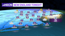
Clouds will be on the increase overnight with diminishing winds as high pressure shifts east with temperatures dropping into the upper 20s north, and mid to upper 30s south with some interior spots around freezing.
Get Boston local news, weather forecasts, lifestyle and entertainment stories to your inbox. Sign up for NBC Boston’s newsletters.
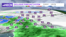
Clouds thicken early Sunday morning and into the early afternoon as low pressure approaches from the west.
Rain showers will break out across western areas of New England, with a bit of snow across the higher elevations, and shift to the east by the early afternoon as a plain rain.
Temperatures will be slightly cooler than today with highs in the upper 40s to around 50 south, mid 40s north, and cooler across the higher elevations.
In terms of snowfall, our inhouse exclusive model is forecasting a very minor event with a coating to an inch or so across the Berkshires into the southern Green Mountains of Vermont and into the White Mountains of New Hampshire through Sunday night.
Showers will end Sunday night from west to east, a few wet snow flakes may mix in across the higher elevations north of Route 2 in Massachusetts points north, but not expecting any accumulations as precipitation shuts down during the overnight.
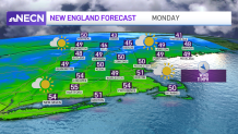
The new work week starts out dry with slightly above average temperatures both Monday and Tuesday as a wedge of high pressure builds into the region.
The middle to the end of the week is looking unsettled with showers arriving late Tuesday into Wednesday with another round of rain looking likely Thursday into Friday as featured on our Exclusive 10-Day forecast!