
A cold front drapes itself across southern New England for the predawn hours Thursday.
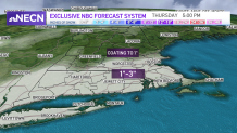
The peak snow accumulation for southern New England will be 5 a.m. to noon. Temperatures will be around freezing near the Mass. Pike, but near 40 still along the south coast.
Temperatures slowly fall, and the rain changes to a mix then snow, leading to the lighter side of snow totals for southern Connecticut, Rhode Island, Cape Cod & the islands. Areas that see the higher side of the snow may be just south of the Pike, and inland, so places like Brockton, the Blackstone Valley, northern Connecticut and northern Rhode Island.
Get Boston local news, weather forecasts, lifestyle and entertainment stories to your inbox. Sign up for NBC Boston’s newsletters.
The snow is steady with about 1-3" widespread accumulation for Worcester, Boston, Hartford, and Providence. Isolated areas may see 4" of snow depending on where some higher bursts set up. The morning commute will be slow-going with the snowfall. Then the snow tapers off north to south and by late afternoon the south coast will have some lingering snow or a light wintry mix as temps rise to just above freezing. The northerly wind off the outer Cape increases and this will allow for some ocean effect snow showers Thursday night.
Friday is a dry day with sunshine and once again cold temps. Highs only reach the single digits and teens, with some subzero wind chills expected. We were watching a storm system off the coast for Saturday, and now the forecast models are trending even farther offshore to our south. We still could see a graze of light snow and gusty winds across southeastern New England for Saturday, but the snow totals are decreasing at this time. Our NBC forecast model does have a 30-40% chance for snow in Boston, while Cape Cod has over a 50% chance of snow.
Weather Stories


Sunday through the start to next week remains quiet with temps around 30 degrees, to the mid-20s by midweek. A minor system moves through midweek, bringing in a quick wintry mix.
