It’s only one day, but we’re expecting a dazzler.
Warm air was surging north overnight. We bottomed out in the 40s during the evening, but rose to the 50s by late evening. With plenty of sun (of limited duration), we’re soaring to near 70 degrees in many spots this afternoon.
STAY IN THE KNOW
Watch NBC10 Boston news for free, 24/7, wherever you are. |
|
Get Boston local news, weather forecasts, lifestyle and entertainment stories to your inbox. Sign up for NBC Boston’s newsletters. |
Records in Boston and Worcester stand at 73 and 68, respectively. We’re technically close to those numbers (70/71 Boston and 65 Worcester), but we’re not planning on reaching those values.
Get top local stories in Boston delivered to you every morning. Sign up for NBC Boston's News Headlines newsletter.
Just as quickly as the warm air moves in, it will be moving out tomorrow morning. A sharp, well-defined front is rushing to the coast late tonight.
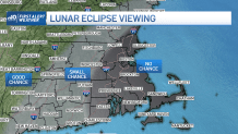
Ironically, the front will pass THEN the showers will move through. This is what we call post-frontal precipitation and it will drag through during the worst possible time for our lunar eclipse.
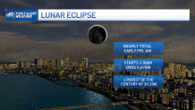
The eclipse time frame runs from 2 a.m. to 5 a.m. tomorrow morning. That’s precisely the time that our steadiest showers will be passing through.
Although for most of western New England, the chances are greater for the skies to break at some point around mid/late eclipse, thanks to the front moving out of that area first. Unfortunately, that means the chances are much smaller for us in Eastern New England. Welp, there’s always May of next year.
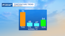
Colder air on a gusty northwest wind will suppress any warmup on Friday. Tons of sun is expected, but we’ll only muster upper 40s. It’s a bit cooler going into the weekend, but Sunday sees us bump into the 50s by afternoon.
Weather Stories

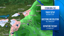
There’s a lot of whispering about the potential for a big storm Monday and Tuesday. It MAY indeed form, but it seem that should be happening far to our east. That puts us in a mild rain on Monday and quick clearing with a sharply colder airmass Tuesday.
Still some time to sort this out and there could be more subtle tweaks to the forecast, so stay tuned.