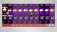
After enjoying another fantastic afternoon along with filtered sunshine and highs that climbed to the upper 40s and 50s, we’re getting ready for a busy Saturday.
What is the timing of Saturday's snow?
Get Boston local news, weather forecasts, lifestyle and entertainment stories to your inbox. Sign up for NBC Boston’s newsletters.
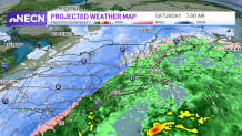
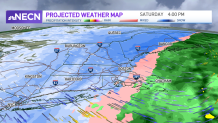
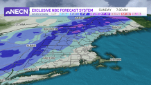
We’ll be on First Alert during our next snow storm which promises to bring plowable snow north, wind gusts and plenty of rain south. Most of New England is expecting to get its share of snow, but not all will watch the snow in the morning. The flurries begin in northwestern New England. Vermont will see the precipitation start early in the morning and as we advance the time stamp to midday, the snow line pushes into the Berkshires and finishes to cover Vermont, where it begins to stretch into central/southern New Hampshire and Maine. By 4 p.m. the snow will already be over most of Massachusetts, Boston is expecting the snow around 4 to 6 p.m. as temperatures drop. While the snowline will reach the southern states as well, the snowfall amounts will be limited here considering that the system will lose its moisture and begin to push out of the area. We’re likely watching the snow leaving by 12 a.m. for much of New England except the north and northeast that may still watch some snow at 4 a.m.
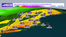
How much snow will New England get?
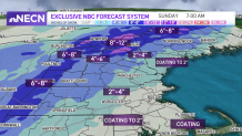
All of this will allow for the highest snowfall amounts to remain north: we’ll see 8-12 inches in the highest mountains of New Hampshire, Vermont and Maine. While central New England will range between 4-6” with higher amounts in the Berkshires, we could end up with 8” there in the west. Worcester and surrounding communities may also watch for over 4" but the southern states are likely waking up to a coating to 3."
Heavy, wet snow and strong winds could cause power outages
Weather Stories


Wet snow and strong wind gusts may bring scattered outages, choppy shores and our visibilities along with slick roads may bring travel impacts.
Our Sunday will be bright and cold, our highs will climb to the upper 30s but feel like the teens north to the low 20s south. Monday will be milder with highs reaching the 40s and 50s again with mostly sunny skies. Take a look at our Exclusive 10-day forecast and stay up to date with your First Alert Team on NBC10 and NECN. Stay safe.