
Looking back at winter so far, Boston has experienced significant temperature fluctuations and limited snowfall opportunities.
The largest snowfall occurred on Jan. 7, measuring 3.8 inches. The following week, a record-breaking high temperature of 60 degrees was recorded, followed by the city's second-largest snowfall at 3.5 inches three days after that. The frequent temperature swings make it challenging to observe consistent snowfall.
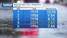
While snow totals since Dec. 1 do not stack up compared to the average snowfall, it is not due to a lack of precipitation. January 2024 ranked as the fourth wettest January on record, with considerable rainfall.
Get Boston local news, weather forecasts, lifestyle and entertainment stories to your inbox. Sign up for NBC Boston’s newsletters.
This trend can be attributed, at least in part, to climate change. Winter is warming at a faster rate than other season, particularly in the northern tier of the country, traditionally known for its colder temperatures.
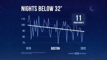
According to research by Climate Central, Boston now averages 11 fewer nights below freezing compared to the 1970s.
This doesn't imply that cold weather and snow will disappear, but the trends suggest not only less frequent cold and frigid snaps, such as the one experienced in mid-January, but also quicker rebounds. This makes the window of opportunity for a good snowstorm smaller.
The coldest stretch so far this season lasted for five days, with temperatures fully below freezing and reaching a record low of 14 degrees on Jan. 20. This was the longest below freezing stretch in two years. Within five days, Boston's temperatures rebounded to the low 50s for highs.


